The Natural Terrestrial Vegetation of Tennessee Project
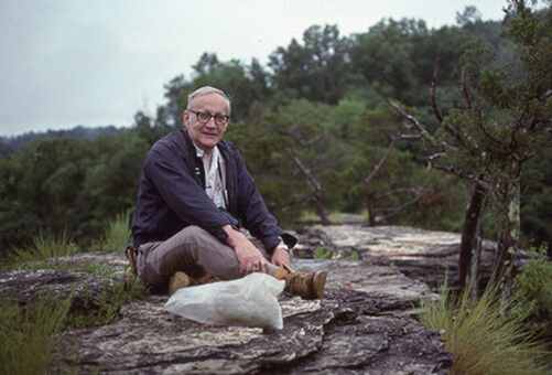
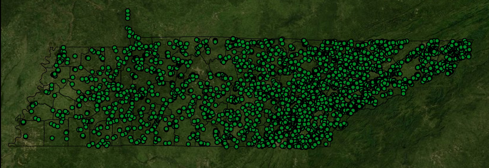
Tennessee is the richest inland state in the nation in terms of biodiversity. The integrity of its diverse ecosystems, however, is threatened by many issues. Urban sprawl, nonnative pests, and pollution are altering natural sites at an alarming rate under a changing climate. To protect Tennessee’s rich biological heritage, we need to understand its ecosystem structure and function. Restoring degraded habitats requires quantitative measurements of reference sites that best represent the ecological potential of the area. Unfortunately, the only comprehensive work on the natural terrestrial vegetation of Tennessee was not available to the organizations engaged in conservation and restoration efforts across the state prior to 2015. Professor Hal De Selm (deceased 7/12/2011) compiled the most comprehensive sample of the natural vegetation communities of Tennessee in existence. As a distinguished conservation biologist and professor of botany and ecology at the University of Tennessee, he was responsible for the conservation of some of Tennessee’s rarest ecosystems. In addition to his academic work, Dr. De Selm is perhaps best known among his friends and colleagues for his dedication to characterizing the natural heritage of Tennessee during his career and in the years following retirement. Dr. De Selm worked tirelessly to measure remnant vegetation communities across the state. He sampled over 3000 sites, primarily in old growth forests, but also in wetlands, floodplains, barrens, and glades. The body of his work occurred from 1956 – 2002 and he catalogued many reference sites that no longer exist in their natural state (e.g., conversion to development). Remarkably, this work was largely funded by Dr. De Selm and his wife, Bea De Selm with no external help. It was a labor of love. These data are a treasure to the state of Tennessee, as was he.
Dr. De Selm envisioned using his data to compose a definitive book: The Natural Terrestrial Vegetation of Tennessee, but his death kept him from realizing his dream. Over four years, UT- TIP converted his original, hand-written field sheets and over 600 quadrangle topographic maps into a database. These data have been transferred to the Tennessee Department of Conservation, Natural Heritage Program to be shared with all those who might use it for natural resource conservation. Professor De Selm’s original papers are archived in the University of Tennessee Library Archives.
NOTE:
– If you would rather receive a copy of a spreadsheet by email rather than direct download please contact me at amains@utk.edu.
– Images of all datasheets and topographic maps depicting sampling locations are available on request.
– Images of Arnold Engineering Development Center Wildlife Management area datasheets and maps are available on request. These points were not included in the database since there were no spatial data.
Acknowledge use of this database as follows:
Mains, A., Ferro, B., and Schlarbaum, S.E. “The Natural Terrestrial Vegetation of Tennessee Project Database“, Natural Resources Conservation Service and The University of Tennessee Tree Improvement Program, 2016.
De Selm Methods
Dr. De Selm documented his methodology for data collection. Please refer to the following document for these methods.
Link to pdf document.
Helpful Information
DataAndDatabaseInformation.092816 – 11/18/13 added ecoregion notes- 01/09/14 added plant code note
– 08/25/15 added notes about Ostrya and Carolina Hickory data issues
– 09/04/15 added notes about buckbush, bub bush, and buckthorn- 09/28/16 added notes up slope and down slope
FIPS Table:
FIPSCodes.091616
– 05/17/13: Added Madison Co and Mitchell Co. in NC for 4 points
– 11/18/13: Added Jackson Co. in AL for 1 point
– 01/03/14: Added Murray Co. in GA for 4 points
– 09/16/16: Added Trigg Co. in KY for 6 points
Plant Code Table:
PlantCodes.091616
– This will be updated with each new county since plant codes are added with each county
– 09/03/15 Corrected codes for Carolina Hickory
– 09/04/15 corrected codes for buckbush, bub bush, and buckthorn
– 11/02/15 corrected Rudebeckia code
– 09/16/16 removed ROSA3 and ROSA7
All Counties data (4183 total samples, 3656 plots):
– changes reflect new counties added and any errors listed below in the individual counties
AllSiteData.112816
AllTreeDataSet1.112816 (broken into 5 for export issue)
AllTreeDataSet2.112816 (broken into 5 for export issue)
AllTreeDataSet3.112816 (broken into 5 for export issue)
AllTreeDataSet4.112816 (broken into 5 for export issue)
AllTreeDataSet5.112816 (broken into 5 for export issue)
AllUnderstoryTreeData.112816
AllShrubData.112816
AllHerbaceousDataSet1.112816 (broken into 2 for export issue)
AllHerbaceousDataSet2.112816(broken into 2 for export issue)
– 08/21/13 corrected some coordinates; corrected topo name typos
– 08/29/13 corrected topo name typos
– 09/11/13 reconciled aspects to proper slope angle % AND separated grazed from deer browsed
– 09/26/13 added McMinn; reconciled Phys Region Code
– 10/03/13 added Fentress
-11/18/13 added ecoregion data for Alexander, Bradley, Blount
-01/03/14 added Cumberland data and changed ecoregion codes
-01/09/14 Bradley and Cumberland coordinate data correction
-02/17/14 Knox added; plant code Dioscorea quaternata corrected and Sevier Co DBH error corrected
-02/26/14 Corrected Knox County TopoMap Name
-12/16/14 AllTreeDataSet3 extra ID field removed
-04/10/15 partial data deletion of Unicoi was replaced
– 08/25/15 HerbaceousDataSet1 and 2 corrections with Lycopodium plant code
– 09/04/15 corrected codes for buckbush, bub bush, and buckthorn
– 09/08/15 changed spatial data on one point and point renumbering
– 11/02/15 corrected tree species missing data
– 11/13/15 corrected hackberry species
– 01/06/16 plant code corrected in Rutherford Co and Franklin Co tree trait typo
– 01/13/16 inkberry changed from Ilex glabra to Pokeweed; tree data typo correction
– 04/14/16 tree data sets were corrected for a one record overlap
– 09/28/16 corrected topo map typo
– 09/29/16 corrected hardcopy index
– 09/30/16 corrected herbaceous errors of Anderson Co.
– 11/28/16 corrected folder#, spatial data, ecotype, and topo map name errors and 1 point was deleted.
Anderson (77 samples):
AndersonSiteData.112816
AndersonTreeData.111315
AndersonUnderstoryTreeData.111315
AndersonShrubData.090315
AndersonHerbaceousData.903016
– 05/17/13 error in herbaceous plant code; dehi3 changed to dehe3
– 05/20/13 access glitch with field duplication
– 08/21/13 corrected some coordinates; corrected topo name typos
– 09/11/13 reconciled aspects to proper slope angle % AND separated grazed from deer browsed
– 09/26/13 reconciled Phys Region Code
– 11/18/13 added Phys Region code to null fields
– 01/03/14 changed ecoregion codes
– 02/17/14 plant code Dioscorea quaternata corrected
– 03/28/14 points added from Cumberland Plateau
– 10/14/14 plant code error with Cimicifuga
– 08/25/15 tree code corrections with Carya carolinae-septentrionalis
– 09/03/15 shrub error coding correction
– 11/13/15 corrected hackberry species
– 09/30/16 corrected herbaceous errors
– 11/28/16 corrected topographic map name errors
Bedford (27 samples)
BedfordSiteData.112816
BedfordTreeData.010616
BedfordUnderstoryTreeData.010616
BedfordShrubData.010616
BedfordHerbaceousData.011316
– 01/13/16 inkberry changed from Ilex glabra to Pokeweed
– 11/28/16 corrected topographic map name errors
Benton (16 samples)
BentonSiteData.112816
BentonTreeData.091616
BentonUnderstoryTreeData.091616
BentonShrubData.091616
BentonHerbaceousData.091616
– 11/28/16 corrected topographic map name errors
Bledsoe (64 samples)
BledsoeSiteData.082115
BledsoeTreeData.111315
BledsoeUnderstoryTreeData.111315
BledsoeShrubData.090315
BledsoeHerbaceousData.041215
– spatial data were off for many points; obvious errors were corrected but others may still have errors
– 08/21/15 added eco regions data
– 09/03/15 shrub error coding correction
– 11/13/15 corrected hackberry species
Blount (153 samples):
BlountSiteData.010314
BlountTreeData.111315
BlountUnderstoryTreeData.111315
BlountShrubData.091916
BlountHerbaceousData.110215
– 05/17/13 error in herbaceous plant code; euse changed to euse2
– 05/20/13 access glitch with field duplication
– 08/21/13 corrected some coordinates
– 08/29/13 corrected topo name typos
– 09/11/13 reconciled aspects to proper slope angle % AND separated grazed from deer browsed
– 09/26/13 reconciled Phys Region Code
– 11/18/13 added Phys Region code to null fields
– 01/03/14 changed ecoregion codes
– 10/14/14 plant code error with Cimicifuga and Umbelliferae
– 02/03/15 plant code OPCO10 changed to OPCP12 and SPAS2 to SPAS
– 08/25/15 tree code corrections with Carya carolinae-septentrionalis
– 09/03/15 shrub error coding correction
– 11/02/15 corrected Rudebeckia code
– 11/13/15 corrected hackberry species
– 09/19/16 deleted ROSA3 shrub error
Bradley (134 samples):
BradleySiteData.112816
BradleyTreeData.111315
BradleyUnderstoryTreeData.111315
BradleyShrubData.091916
BradleyHerbaceousData.110215
– 05/17/13 error in herbaceous plant code; dehi3 changed to dehe3
– 08/21/13 corrected topo name typos
– 09/11/13 reconciled aspects to proper slope angle % AND separated grazed from deer browsed
– 11/18/13 added Phys Region code to null fields
– 01/03/14 changed ecoregion codes
– 01/09/14 coordinate data correction
– 02/17/14 plant code Dioscorea quaternata corrected
– 08/25/15 tree code corrections with Carya carolinae-septentrionalis
– 09/03/15 shrub error coding correction
– 11/02/15 corrected Rudebeckia code
– 11/13/15 corrected hackberry species
– 11/28/16 corrected topographic map name errors
Campbell (77 samples):
CampbellSiteData.092816
CampbellTreeData.111315
CampbellUnderstoryTreeData.111315
CampbellShrubData.091916
CampbellHerbaceousData.110215
– 05/17/13 error in lat/longs of two points corrected
– 05/20/13 access glitch with field duplication
– 08/21/13 corrected some coordinates
– 09/11/13 reconciled aspects to proper slope angle % AND separated grazed from deer browsed
– 01/03/14 changed ecoregion codes
– 02/03/15 plant code SPAS2 changed to SPAS
– 11/02/15 corrected Rudebeckia code; added 47 new sample points
– 11/13/15 corrected hackberry species
– 09/19/16 deleted ROSA3 shrub error
– 09/28/16 corrected topo map typo
Cannon (28 samples)
CannonSiteData.092816
CannonTreeData.041316
CannonUnderstoryTreeData.041316
CannonShrubData.041316
CannonHerbaceousData.041316
– 09/28/16 corrected topo map typo
Carroll (28 samples)
CarrollSiteData.112816
CarrollTreeData.091616
CarrollUnderstory TreeData.091616
CarrollShrubData.091616
CarrollHerbaceousData.091616
– 11/28/16 corrected topographic map name errors
Carter (60 samples)
CarterSiteData.112816
CarterTreeData.051713
CarterUnderstoryTreeData.052013
CarterShrubData.052013
CarterHerbaceousData.082515
– 08/21/13 corrected topo name typos
– 09/11/13 reconciled aspects to proper slope angle % AND separated grazed from deer browsed
– 01/03/14 changed ecoregion codes
– 10/14/14 plant code error with Cimicifuga
– 08/25/15 plant code corrections with Lycopodium
– 11/28/16 corrected topographic map name errors
Cheatham (19 samples)
CheathamSiteData.092916
CheathamTreeData.041316
CheathamUnderstoryTreeData.041316
CheathamShrubData.041316
CheathamHerbaceousData.041316
– 09/29/16 corrected hardcopy index
Chester (6 samples)
ChesterSiteData.091616
ChesterTreeData.091616
ChesterUnderstoryTreeData.091616
ChesterShrubData.091616
ChesterHerbaceousData.091616
Claiborne (143 samples)
ClaiborneSiteData.092816
ClaiborneTreeData.111315
ClaiborneUnderstoryTreeData.111315
ClaiborneShrubData.091916
ClaiborneHerbaceousData.110215
– 09/03/15 shrub error coding correction
– 09/04/15 point correction
– 11/02/15 corrected Rudebeckia code
– 11/13/15 corrected hackberry species
– 01/06/16 deleted non-existent plot
– 09/19/16 deleted ROSA3 shrub error
– 09/28/16 corrected topo map typo
Clay (27 samples)
ClaySiteData.051414
ClayTreeData.082515
ClayUnderstoryTreeData.111315
ClayShrubData.090315
ClayHerbaceousData.051414
– 09/03/15 shrub error coding correction
– 11/13/15 corrected hackberry species
Cocke (78 samples)
CockeSiteData.120214
CockeTreeData.111315
CockeUnderstoryTreeData.111315
CockeShrubData.091916
CockeHerbaceousData.120214
– 09/03/15 shrub error coding correction
– 09/19/16 deleted ROSA3 shrub error
Coffee (45 samples)
CoffeeSiteData.051414
CoffeeTreeData.111315
CoffeeUnderstoryTreeData.111315
CoffeeShrubData.090315
CoffeeHerbaceousData.051414
– 09/03/15 shrub error coding correction
– 11/13/15 corrected hackberry species
Crockett (4 samples)
CrockettSiteData.091616
CrockettTreeData.091616
CrockettUnderstoryTreeData.091616
CrockettShrubData.091616
CrockettHerbaceousData.091616
Cumberland (57 samples)
CumberlandSiteData.010914
CumberlandTreeData.010314
CumberlandUnderstoryTreeData.111315
CumberlandShrubData.090315
CumberlandHerbaceousData.010314
– 01/09/14 coordinate data correction
– 09/03/15 shrub error coding correction
– 11/13/15 corrected hackberry species
Davidson (21 samples)
DavidsonSiteData.101414
DavidsonTreeData.111315
DavidsonUnderstoryTreeData.111315
DavidsonShrubData.091916
DavidsonHerbaceousData.011316
– 09/03/15 shrub error coding correction
– 11/13/15 corrected hackberry species
– 11/13/15 corrected hackberry species
– 01/13/16 inkberry changed from Ilex glabra to Pokeweed
– 09/19/16 deleted ROSA3 shrub error
Decatur (19 samples)
DecaturSiteData.091616
DecaturTreeData.091616
DecaturUnderstoryTreeData.091616
DecaturShrubData.091616
DecaturHerbaceousData.091616
DeKalb (41 samples)
DeKalbSiteData.112816
DeKalbTreeData.111315
DeKalbUnderstoryTreeData.111315
DeKalbShrubData.110215
DeKalbHerbaceousData.110215
– 11/13/15 corrected hackberry species
– 11/28/16 corrected topographic map name and spatial data errors
Dickson (29 samples)
DicksonSiteData.092816
DicksonTreeData.091916
DicksonUnderstoryData.091916
DicksonShrubData.091916
DicksonHerbaceousData.091916
– 10/14/14 plant code error with Umbelliferae
– 09/03/15 shrub error coding correction
– 11/13/15 corrected hackberry species
– 01/13/16 inkberry changed from Ilex glabra to Pokeweed
– 09/19/16 added missing spatial data; added extra point
– 09/28/16 corrected topo map typo
Dyer (10 samples)
DyerSiteData.051414
DyerTreeData.051414
DyerUnderstoryData.051414
DyerShrubData.051414
DyerHerbaceousData.051414
Fayette (8 samples)
FayetteSiteData.091616
FayetteTreeData.091616
FayetteUnderstoryTreeData.091616
FayetteShrubData.091616
FayetteHerbaceousData.091616
Fentress (43 samples)
FentressSiteData.112816
FentressTreeData.082115
FentressUnderstoryTreeData.111315
FentressShrubData.091916
FentressHerbaceousData.082115
– 01/03/14 changed ecoregion codes
– 02/03/15 plant code OPCO10 changed to OPCP12
– 08/21/15 added one new sample point
– 11/13/15 corrected hackberry species
– 09/19/16 deleted ROSA3 shrub error
– 11/28/16 corrected folder # errors
Franklin (62 samples)
FranklinSiteData.112816
FranklinTreeData.010616
FranklinUnderstoryTreeData.111315
FranklinShrubData.091916
FranklinHerbaceousData.092514
– 01/03/14 changed ecoregion codes
– 09/25/14 added 24 points
– 09/03/15 shrub error coding correction
– 11/13/15 corrected hackberry species
– 01/06/16 tree trait data type
– 09/19/16 added missing spatial data; deleted ROSA3 shrub error
– 11/28/16 corrected folder # errors
Gibson (13 samples)
GibsonSiteData.091616
GibsonTreeData.091616
GibsonUnderstoryTreeData.091616
GibsonShrubData.091616
GibsonHerbaceousData.091616
Giles (18 samples)
GilesSiteData.112816
GilesTreeData.112014
GilesUnderstoryTreeData.111315
GilesShrubData.091916
GilesHerbaceousData.011316
– 11/20/14 six points were off their sample sites by some distance and were corrected using De Selm’s notes and points drawn on County Hwy map. Road names did not match between paper map and ArcMap images. There was no topo map available for these points.
– 09/03/15 shrub error coding correction
– 11/02/15 corrected Rudebeckia code
– 11/13/15 corrected hackberry species
– 01/13/16 inkberry changed from Ilex glabra to Pokeweed
– 09/19/16 deleted ROSA3 shrub error
– 11/28/16 corrected spatial data errors
Grainger (58 samples)
GraingerSiteData.010314
GraingerTreeData.111315
GraingerUnderstoryTreeData.110713
GraingerShrubData.091916
GraingerHerbaceousData.020315
– 01/03/14 changed ecoregion codes
– 02/17/14 plant code Dioscorea quaternata corrected
– 10/14/14 plant code error with Cimicifuga
– 02/03/15 plant code OPCO10 changed to OPCP12
– 09/03/15 shrub error coding correction
– 11/13/15 corrected hackberry species
– 09/19/16 deleted ROSA3 shrub error
Greene (54 samples)
GreeneSiteData.101414
GreeneTreeData.082515
GreeneUnderstoryTreeData.111315
GreeneShrubData.101414
GreeneHerbaceousData.101414
– 11/13/15 corrected hackberry species
– 09/19/16 deleted ROSA3 shrub error
Grundy (24 samples)
GrundySiteData.012715
GrundyTreeData.111315
GrundyUnderstoryTreeData.111315
GrundyShrubData.090315
GrundyHerbaceousData.012715
– 09/03/15 shrub error coding correction
– 11/13/15 corrected hackberry species
Hamblen (9 samples)
HamblenSiteData.041015
HamblenTreeData.082515
HamblenUnderstoryTreeData.111315
HamblenShrubData.012715
HamblenHerbaceousData.012715
– 04/10/15 Added missing ecoregion data
– 11/13/15 corrected hackberry species
Hamilton (79 samples)
HamiltonSiteData.082115
HamiltonTreeData.111315
HamiltonUnderstoryTreeData.111315
HamiltonShrubData.090315
HamiltonHerbaceousData.110215
– 09/11/13 reconciled aspects to proper slope angle % AND separated grazed from deer browsed
– 01/03/14 changed ecoregion codes
– 08/21/15 added 22 new sample points
– 08/25/15 tree code corrections with Carya carolinae-septentrionalis
– 09/03/15 shrub error coding correction
– 11/02/15 corrected Rudebeckia code
– 11/13/15 corrected hackberry species
Hancock (212 samples)
HancockSiteData.091916
HancockTreeData.111315
HancockUnderstoryTreeData.111315
HancockShrubData.091916
HancockHerbaceousData.090815
– 09/03/15 shrub error coding correction
– 09/08/15 changed spatial data on one point and point renumbering
– 11/13/15 corrected hackberry species
– 09/19/16 added missing spatial data; deleted ROSA3 shrub error
Hardeman (14 samples)
HardemanSiteData.091616
HardemanTreeData.091616
HardemanUnderstoryTreeData.091616
HardemanShrubData.091616
HardemanHerbaceousData.091616
Hardin (16 samples)
HardinSiteData.091616
HardinTreeData.091616
HardinUnderstoryTreeData.091616
HardinShrubData.091616
HardinHerbaceousData.091616
Hawkins (22 samples)
HawkinsSiteData.061915
HawkinsTreeData.061915
HawkinsUnderstoryTreeData.111315
HawkinsShrubData.090315
HawkinsHerbaceousData.061915
– 09/03/15 shrub error coding correction
– 11/13/15 corrected hackberry species
Haywood (9 samples)
HaywoodSiteData.091616
HaywoodTreeData.091616
HaywoodUnderstoryTreeData.091616
HaywoodShrubData.091616
HaywoodHerbaceousData.091616
Henderson (23 samples)
HendersonSiteData.091616
HendersonTreeData.091616
HendersonUnderstoryTreeData.091616
HendersonShrubData.091616
HendersonHerbaceousData.091616
Henry (23 samples)
HenrySiteData.091616
HenryTreeData.091616
HenryUnderstoryTreeData.091616
HenryShrubData.091616
HenryHerbaceousData.091616
Hickman (24 samples)
HickmanSiteData.112816
HickmanTreeData.112014
HickmanUnderstoryTreeData.111315
HickmanShrubData.090315
HickmanHerbaceousData.011316
– 09/03/15 shrub error coding correction
– 11/13/15 corrected hackberry species
– 01/13/16 inkberry changed from Ilex glabra to Pokeweed
– 09/19/16 deleted ROSA3 shrub error
– 11/28/16 corrected topographic map name
Houston (21 samples)
HoustonSiteData.112816
HoustonTreeData.112014
HoustonUnderstoryTreeData.111315
HoustonShrubData.090315
HoustonHerbaceousData.011316
– 11/20/14 note on spatial data, all points were off their sample sites by some distance when compared with topo maps. All were corrected by using landmarks on topo maps.
– 09/03/15 shrub error coding correction
– 11/13/15 corrected hackberry species
– 01/13/16 inkberry changed from Ilex glabra to Pokeweed
– 09/19/16 added missing spatial data
– 11/28/16 corrected spatial data
Humphreys (22 samples)
HumphreysSiteData.041316
HumphreysTreeData.041316
HumphreysUnderstoryTreeData.041316
HumphreysShrubData.091916
HumphreysHerbaceousData.041316
– 09/19/16 deleted ROSA3 and ROSA7 shrub error
Jackson (24 samples)
JacksonSiteData.010616
JacksonTreeData.010616
JacksonUnderstoryTreeData.010616
JacksonShrubData.010616
JacksonHerbaceousData.011316
– 01/13/16 inkberry changed from Ilex glabra to Pokeweed
Jefferson (52 samples)
JeffersonSiteData.092816
JeffersonTreeData.111315
JeffersonUnderstoryTreeData.111315
JeffersonShrubData.090315
JeffersonHerbaceousData.020315
– 01/03/14 changed ecoregion codes
– 10/14/14 plant code error with Cimicifuga
– 02/03/15 plant code SPAS2 changed to SPAS
– 08/25/15 tree code corrections with Carya carolinae-septentrionalis
– 09/03/15 shrub error coding correction
– 11/13/15 corrected hackberry species
– 09/19/16 deleted ROSA3 shrub error
– 09/28/16 corrected topo map typo
Johnson (54 samples)
JohnsonSiteData.092816
JohnsonTreeData.061915
JohnsonUnderstoryTreeData.061915
JohnsonShrubData.061915
JohnsonHerbaceousData.061915
– 09/28/16 corrected topo map typo
Knox (255 samples)
KnoxSiteData.112816
KnoxTreeData.111315
KnoxUnderstoryTreeData.111315
KnoxShrubData.091916
KnoxHerbaceousData.011316
– 02/26/14 Corrected Knox County TopoMap Name
– 10/14/14 plant code error with Cimicifuga and Umbelliferae
– 02/03/15 plant code SPAS2 changed to SPAS
– 09/03/15 shrub error coding correction
– 11/13/15 corrected hackberry species
– 01/06/16 spatial data correction
– 01/13/16 inkberry changed from Ilex glabra to Pokeweed
– 09/19/16 added missing spatial data; deleted ROSA3 shrub error
– 11/28/16 corrected topographic map name error
Lauderdale (13 samples)
LauderdaleSiteData.112816
LauderdaleTreeData.112816
LauderdaleUnderstoryData.112816
LauderdaleShrubData.112816
LauderdaleHerbaceousData.112816
– 01/03/14 changed ecoregion codes
– 11/13/15 corrected hackberry species
– 01/13/16 inkberry changed from Ilex glabra to Pokeweed
– 11/28/16 corrected spatial data and deleted all vegetation and site data in point labeled 93-287
Lawrence (24 samples)
LawrenceSiteData.041316
LawrenceTreeData.041316
LawrenceUnderstoryTreeData.041316
LawrenceShrubData.091916
LawrenceHerbaceousData.091916
– 09/19/16 corrected fern plant code; deleted ROSA3 shrub error
Lewis (20 samples)
LewisSiteData.041316
LewisTreeData.041316
LewisUnderstoryTreeData.041316
LewisShrubData.041316
LewisHerbaceousData.041316
Lincoln (29 samples)
LincolnSiteData.041316
LincolnTreeData.041316
LincolnUnderstoryTreeData.041316
LincolnShrubData.091916
LincolnHerbaceousData.041316
– 09/19/16 deleted ROSA3 shrub error
Loudon (42 samples)
LoudonSiteData.041614
LoudonTreeData.111315
LoudonUnderstoryTreeData.111315
LoudonShrubData.091916
LoudonHerbaceousData.041614
– 11/13/15 corrected hackberry species
– 09/19/16 deleted ROSA3 shrub error
Macon (26 samples)
MaconSiteData.010616
MaconTreeData.010616
MaconUnderstoryTreeData.010616
MaconShrubData.010616
MaconHerbaceousData.011316
– 01/13/16 inkberry changed from Ilex glabra to Pokeweed
Madison (23 samples)
MadisonSiteData.091616
MadisonTreeData.091616
MadisonUnderstoryTreeData.091616
MadisonShrubData.091616
MadisonHerbaceousData.091616
Marion (58 samples)
MarionSiteData.010314
MarionTreeData.111315
MarionUnderstoryTreeData.111315
MarionShrubData.090315
MarionHerbaceousData.020315
– 01/03/14 changed ecoregion codes
– 02/03/15 plant code OPCO10 changed to OPCP12 and SPAS2 to SPAS
– 09/03/15 shrub error coding correction
– 11/13/15 corrected hackberry species
Marshall (15 samples)
MarshallSiteData.041316
MarshallTreeData.041316
MarshallUnderstoryTreeData.041316
MarshallShrubData.091916
MarshallHerbaceousData.041316
– 09/19/16 deleted ROSA3 shrub error
Maury (26 Samples)
MaurySiteData.041316
MauryTreeData.041316
MauryUnderstoryTreeData.041316
MauryShrubData.091916
MauryHerbaceousData.041316
– 09/19/16 deleted ROSA3 shrub error
McMinn (50 samples)
McMinnSiteData.082115
McMinnTreeData.111315
McMinnUnderstoryData.111315
McMinnShrubData.091916
McMinnHerbaceousData.110215
– 01/03/14 changed ecoregion codes
– 02/17/14 plant code Dioscorea quaternata corrected
– 08/21/15 added one new sample point
– 11/02/15 corrected Rudebeckia code
– 11/13/15 corrected hackberry species
– 09/19/16 deleted ROSA3 shrub error
McNairy (25 samples)
McNairySiteData.091616
McNairyTreeData.091616
McNairyUnderstoryTreeData.091616
McNairyShrubData.091616
McNairyHerbaceousData.091616
Meigs (117 samples)
MeigsSiteData.092816
MeigsTreeData.010615
MeigsUnderstoryData.111315
MeigsShrubData.091916
MeigsHerbaceousData.110215
– 10/24/14 error in counties included in subset
– 02/03/15 plant code OPCO10 changed to OPCP12
– 09/03/15 shrub error coding correction
– 11/02/15 corrected Rudebeckia code; corrected tree species missing data
– 11/13/15 corrected hackberry species
– 01/06/16 corrected plant code error
– 09/19/16 deleted ROSA3 shrub error
– 09/28/16 corrected topo map typo
Monroe (95 samples)
MonroeSiteData.041015
MonroeTreeData.111315
MonroeUnderstoryTreeData.111315
MonroeShrubData.090315
MonroeHerbaceousData.110215
– 09/03/15 shrub error coding correction
– 11/02/15 corrected Rudebeckia code
– 11/13/15 corrected hackberry species
Montgomery (24 samples)
MontgomerySiteData.092916
MontgomeryTreeData.041316
MontgomeryUnderstoryTreeData.041316
MontgomeryShrubData.041316
MontgomeryHerbaceousData.041316
– 09/29/16 corrected hardcopy index
Moore (4 samples)
MooreSiteData.041316
MooreTreeData.041316
MooreUnderstoryTreeData.041316
MooreShrubData.041316
MooreHerbaceousData.041316
Morgan (41 samples)
MorganSiteData.061915
MorganTreeData.061915
MorganUnderstoryTreeData.061915
MorganShrubData.090315
MorganHerbaceousData.110215
– 09/03/15 shrub error coding correction
– 11/02/15 corrected Rudebeckia code
Obion (17 samples)
ObionSiteData.091616
ObionTreeData.091616
ObionUnderstoryTreeData.091616
ObionShrubData.091616
ObionHerbaceousData.091616
Overton (52 samples)
OvertonSiteData.091916
OvertonTreeData.082115
OvertonUnderstoryTreeData.111315
OvertonShrubData.090315
OvertonHerbaceousData.011316
– 08/21/15 added 23 new sample points
– 09/03/15 shrub error coding correction
– 11/02/15 corrected Rudebeckia code
– 11/13/15 corrected hackberry species
– 01/13/16 inkberry changed from Ilex glabra to Pokeweed
– 09/19/16 added missing spatial data
Perry (27 samples)
PerrySiteData.041316
PerryTreeData.041316
PerryUnderstoryTreeData.041316
PerryShrubData.041316
PerryHerbaceousData.041316
Pickett (13 samples)
PickettSiteData.041316
PickettTreeData.041316
PickettUnderstoryTreeData.041316
PickettShrubData.041316
PickettHerbaceousData.041316
Polk (81 samples)
PolkSiteData.092816
PolkTreeData.111315
PolkUnderstoryTreeData.111315
PolkShrubData.090315
PolkHerbaceousData.061915
– 09/03/15 shrub error coding correction
– 11/13/15 corrected hackberry species
– 09/28/16 corrected topo map typo
Putnam (46 samples)
PutnamSiteData.092816
PutnamTreeData.111315
PutnamUnderstoryTreeData.111315
PutnamShrubData.091916
PutnamHerbaceousData.110215
– 11/13/15 corrected hackberry species
– 09/19/16 added missing spatial data; deleted ROSA3 shrub error
– 09/28/16 corrected topo map typo
Rhea (102 samples)
RheaSiteData.082115
RheaTreeData.111315
RheaUnderstoryData.111315
RheaShrubData.090315
RheaHerbaceousData.082115
– 02/03/15 plant code OPCO10 changed to OPCP12
– 08/21/15 added one new sample point
– 09/03/15 shrub error coding correction
– 11/13/15 corrected hackberry species
– 09/19/16 deleted ROSA3 shrub error
Roane (166 samples)
RoaneSiteData.092514
RoaneTreeData.111315
RoaneUnderstoryData.111314
RoaneShrubData.091916
RoaneHerbaceousData.110215
– 10/14/14 plant code error with Umbelliferae
– 09/03/15 shrub error coding correction
– 11/02/15 corrected Rudebeckia code
– 11/13/15 corrected hackberry species
– 09/19/16 deleted ROSA3 shrub error
Robertson (22 samples)
RobertsonSiteData.041316
RobertsonTreeData.041316
RobertsonUnderstoryTreeData.041316
RobertsonShrubData.091916
RobertsonHerbaceousData.041316
– 09/19/16 deleted ROSA3 shrub error
Rutherford (28 samples)
RutherfordSiteData.112816
RutherfordTreeData.110215
RutherfordUnderstoryTreeData.111315
RutherfordShrubData.110215
RutherfordHerbaceousData.011316
– 11/13/15 corrected hackberry species
– 01/06/16 corrected plant code error
– 01/13/16 inkberry changed from Ilex glabra to Pokeweed
– 09/19/16 added missing spatial data
– 11/28/16 corrected eco region data
Scott (70 samples)
ScottSiteData.041015
ScottTreeData.111315
ScottUnderstoryTreeData.111315
ScottShrubData.091916
ScottHerbaceousData.110215
– spatial data were off for many points; obvious errors were corrected but others may still have errors
– 09/03/15 shrub error coding correction
– 11/02/15 corrected Rudebeckia code
– 11/13/15 corrected hackberry species
– 09/19/16 deleted ROSA3 shrub error
Sequatchie (25 samples)
SequatchieSiteData.010616
SequatchieTreeData.010616
SequatchieUnderstoryTreeData.010616
SequatchieShrubData.010616
SequatchieHerbaceousData.010616
Sevier (89 samples)
SevierSiteData.010314
SevierTreeData.011316
SevierUnderstoryTreeData.111315
SevierShrubData.091916
SevierHerbaceousData.110215
– 08/29/13 corrected topo name typos
– 09/11/13 reconciled aspects to proper slope angle % AND separated grazed from deer browsed
– 01/03/14 changed ecoregion codes
– 02/17/14 tree DBH error corrected
– 10/14/14 plant code error with Cimicifuga
– 08/25/15 tree code corrections with Carya carolinae-septentrionalis
– 11/02/15 corrected Rudebeckia code
– 11/13/15 corrected hackberry species
– 01/13/16 tree data typo correction
– 09/19/16 deleted ROSA3 shrub error
Shelby (9 samples)
ShelbySiteData.010314
ShelbyTreeData.102813
ShelbyUnderstoryTreeData.102813
ShelbyShrubData.102813
ShelbyHerbaceousData.011316
– 01/03/14 changed ecoregion codes
– 01/13/16 inkberry changed from Ilex glabra to Pokeweed
Smith (20 samples)
SmithSiteData.010616
SmithTreeData.010616
SmithUnderstoryTreeData.010616
SmithShrubData.091916
SmithHerbaceousData.010616
– 09/19/16 deleted ROSA3 shrub error
Stewart (28 samples)
StewartSiteData.041316
StewartTreeData.041316
StewartUnderstoryTreeData.041316
StewartShrubData.091916
StewartHerbaceousData.041316
– 09/19/16 deleted ROSA3 shrub error
Sullivan (70 samples)
SullivanSiteData.112816
SullivanTreeData.111315
SullivanUnderstoryTreeData.111315
SullivanShrubData.082115
SullivanHerbaceousData.082115
– 08/21/15 added one new sample point
– 11/13/15 corrected hackberry species
– 09/28/16 corrected topo map typo
– 11/28/16 corrected folder # error
Sumner (17 samples)
SumnerSiteData.092816
SumnerTreeData.041316
SumnerUnderstoryTreeData.041316
SumnerShrubData.091916
SumnerHerbaceousData.041316
– 09/19/16 deleted ROSA3 shrub error
– 09/28/16 corrected topo map typo
Tipton (4 samples)
TiptonSiteData.112816
TiptonTreeData.102813
TiptonUnderstoryTreeData.102813
TiptonShrubData.102813
TiptonHerbaceousData.011316
– 01/03/14 changed ecoregion codes
– 01/13/16 inkberry changed from Ilex glabra to Pokeweed
– 11/28/16 corrected topo map typo
Trousdale (6 samples)
TrousdaleSiteData.041316
TrousdaleTreeData.041316
TrousdaleUnderstoryTreeData.041316
TrousdaleShrubData.041316
TrousdaleHerbaceousData.041316
Unicoi (36 samples)
UnicoiSiteData.112816
UnicoiTreeData.041315
UnicoiUnderstoryTreeData.041315
UnicoiShrubData.041315
UnicoiHerbaceousData.041315
– 04/13/15 added missing data
– 11/28/16 corrected topo map typo
Union (66 samples)
UnionSiteData.112816
UnionTreeData.090315
UnionUnderstoryTreeData.111315
UnionShrubData.090315
UnionHerbaceousData.090315
– 09/11/13 reconciled aspects to proper slope angle % AND separated grazed from deer browsed
– 01/03/14 changed ecoregion codes
– 02/17/14 plant code Dioscorea quaternata corrected
– 09/03/15 vegetation error corrected in point numbers
– 11/13/15 corrected hackberry species
– 01/06/16 corrected spatial data error
– 09/19/16 added missing spatial data
– 11/28/16 corrected topo map typo
Van Buren (34 samples)
VanBurenSiteData.110215
VanBurenTreeData.110215
VanBurenUnderstoryTreeData.111315
VanBurenShrubData.110215
VanBurenHerbaceousData.110215
– 11/13/15 corrected hackberry species
Warren (29 samples)
WarrenSiteData.041614
WarrenTreeData.111315
WarrenUnderstoryTreeData.111315
WarrenShrubData.090315
WarrenHerbaceousData.110215
– 09/03/15 shrub error coding correction
– 11/02/15 corrected Rudebeckia code
– 11/13/15 corrected hackberry species
Washington (52 samples)
WashingtonSiteData.032014
WashingtonTreeData.111315
WashingtonUnderstoryData.111315
WashingtonShrubData.032014
WashingtonHerbaceousData.032014
– 11/13/15 corrected hackberry species
– 09/19/16 deleted ROSA3 shrub error
Wayne (23 samples)
WayneSiteData.041316
WayneTreeData.041316
WayneUnderstoryTreeData.041316
WayneShrubData.091916
WayneHerbaceousData.041316
Weakley (15 samples)
WeakleySiteData.091616
WeakleyTreeData.091616
WeakleyUnderstoryTreeData.091616
WeakleyShrubData.091616
WeakleyHerbaceousData.091616
White (36 samples)
WhiteSiteData.110215
WhiteTreeData.110215
WhiteUnderstoryTreeData.111315
WhiteShrubData.110215
WhiteHerbaceousData.110215
– 11/13/15 corrected hackberry species
Williamson (24 samples)
WilliamsonSiteData.041316
WilliamsonTreeData.041316
WilliamsonUnderstoryTreeData.041316
WilliamsonShrubData.091916
WilliamsonHerbaceousData.041316
Wilson (24 samples)
WilsonSiteData.010616
WilsonTreeData.010616
WilsonUnderstoryTreeData.010616
WilsonShrubData.010616
WilsonHerbaceousData.010616
Counties out of TN
Jackson Co., AL (1 sample)
Lyon Co., KY (3 samples)
Madison Co., NC (2 samples)
Murray Co., GA (4 samples)
Mitchell Co., NC (3 samples)
Trigg Co., KY (6 samples)
OutofTNSiteData.112816
OutofTNTreeData.091916
OutofTNUnderstoryTreeData.091916
OutofTNShrubData.091916
OutofTNHerbaceousData.091916
– 05/20/13 added Mitchell Co., NC plots
– 08/21/13 corrected topo name typos
– 09/11/13 reconciled aspects to proper slope angle % AND separated grazed from deer browsed
– 09/26/13 reconciled Phys Region Code
– 11/18/13 added Jackson Co., Al points
– 01/03/14 changed ecoregion codes
– 09/03/15 shrub error coding correction
– 11/13/15 corrected hackberry species
– 09/19/16 added Lyon Co. and Trigg Co., KY species
– 11/28/16 corrected topograph map name error